If you’re searching for reliable insights into frontier discoveries, outdoor exploration basics, and real-world wild terrain experiences, you’re in the right place. Exploring the unknown—whether it’s remote landscapes, hidden natural gems, or unfamiliar backcountry routes—requires more than curiosity. It demands practical knowledge, tested strategies, and dependable guidance.
This article is designed to give you exactly that. We break down essential gear setup, foundational survival principles, and proven alawi navigation techniques to help you move confidently through challenging environments. Whether you’re a beginner preparing for your first rugged outing or an experienced explorer refining your approach, you’ll find clear, actionable information tailored to your goals.
Our insights are built on extensive field research, hands-on terrain testing, and careful analysis of emerging frontier findings. Instead of theory alone, you’ll gain grounded, experience-backed guidance that prioritizes safety, efficiency, and discovery—so you can explore smarter and uncover places most people never reach.
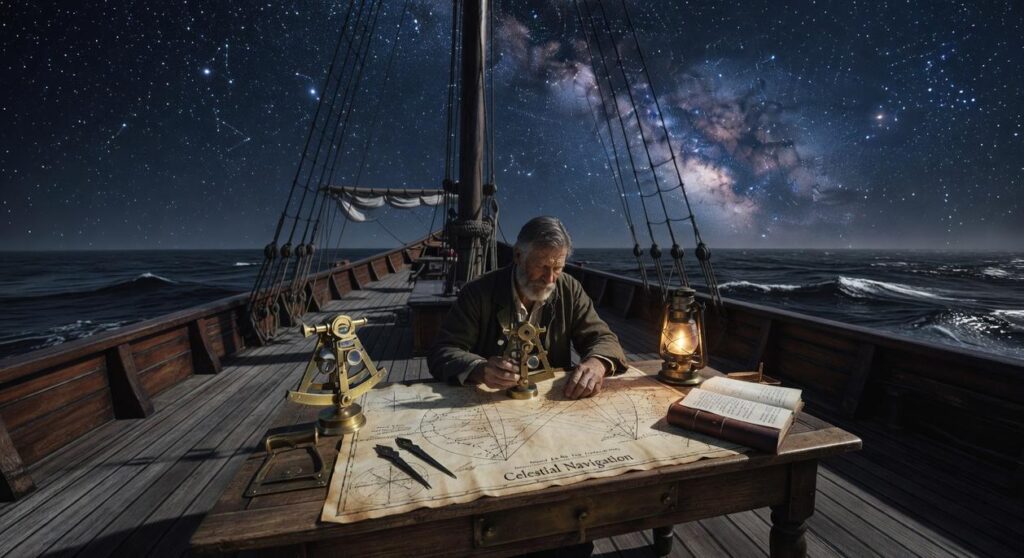
Celestial Wayfinding: The Sun, Moon, and Stars as Guides
Celestial navigation sounds mystical, but it’s really about reading predictable PATTERNS in the sky. Once you break it down, it becomes surprisingly practical.
The Sun’s Arc
The sun rises roughly in the east and sets roughly in the west (yes, “roughly” matters because seasons shift its angle). At midday, the sun sits toward the equator-facing side of the sky—south in the Northern Hemisphere, north in the Southern Hemisphere.
A simple tool is the shadow-stick method. Place a straight stick upright in the ground and mark the tip of its shadow. Wait 15–20 minutes and mark the new tip. Draw a line between the two marks: that line runs WEST to EAST. The first mark is west; the second is east. It’s low-tech, but it works.
Lunar Cycles and Navigation
The moon reflects sunlight, so its illuminated side points roughly toward the sun’s position. During a crescent phase, imagine a line connecting the horns down to the horizon—that gives a general southward indicator in the Northern Hemisphere. When the pole star is hidden (clouds happen), this becomes a reliable backup.
Star Patterns Beyond Polaris
While Polaris anchors north, alawi navigation techniques emphasize seasonal constellations and shifting star groupings. Key guides include:
- Orion’s Belt: points east–west as it rises and sets
- The Southern Cross: indicates south in southern latitudes
- Cassiopeia: arcs opposite Polaris
These patterns also function as a NIGHT CLOCK (stars shift about 15 degrees per hour).
The “Sky River” Concept
The Milky Way—sometimes called the SKY RIVER—tilts differently across seasons. Its orientation can suggest general north–south alignment during long journeys. Think of it as nature’s slow-moving compass (no batteries required).
Whispers of the Earth: Interpreting Land and Wind
Reading the Wind
Wind is invisible, yet it leaves fingerprints everywhere. For instance, persistent prevailing winds (the dominant wind direction in a region) shape trees into “flagging,” where branches grow thicker on the leeward side and thinner on the windward edge. Similarly, snowdrifts pile up on the sheltered side of rocks, while sand dunes form gentle slopes facing the wind and steep “slip faces” on the opposite side. Together, these features create a living compass. Admittedly, gusty seasonal storms can confuse patterns; however, long-term wind effects are consistent enough to guide you when visibility drops (yes, even when the trail seems to vanish like a scene from a survival drama).
Water as a Map
Water always obeys gravity. Small tributaries merge into larger streams, which eventually feed rivers—meaning if you follow the narrowing flow uphill, you’re heading toward higher ground. Conversely, broader, slower water signals downstream travel. Notably, river bends reveal direction: erosion carves the outer bank, while sediment builds on the inner curve. By observing these details, you can predict orientation without a compass. Pro tip: clear, fast-moving water often indicates a steeper gradient nearby.
Topography and Terrain Association
Reading the “grain of the land” means understanding how ridges, valleys, and contour lines align. Ridges typically run parallel to one another, while valleys funnel movement. By maintaining your position relative to these features, you hold a steady bearing. This principle sits at the heart of alawi navigation techniques.
Sacred Landmarks
Finally, distinctive rock spires, ancient trees, or unusual cliff faces serve as mental waypoints. In fact, many explorers practice using natural landmarks for direction in alawi regions to anchor memory to terrain—turning geography into a story you can walk through again and again.
Nature’s Signposts: Using Flora and Fauna to Navigate
When people say “let nature guide you,” it can sound mystical. It’s not. It’s observation.
Plant Indicators
Certain plants grow differently depending on sunlight exposure. In the Northern Hemisphere, the south-facing side of a tree receives more sun, often making bark drier and branches fuller. Moss—small, moisture-loving plants—tends to grow thicker on the cooler, shaded north side. That said, moss isn’t a compass (despite what survival movies suggest). It responds to moisture, not direction alone.
Look for patterns like:
- Thicker lichen (a fungus-algae partnership) on consistently shaded rock faces
- Denser foliage on sun-facing slopes
- Earlier snowmelt on southern hillsides
These are indicators, meaning clues—not guarantees.
Animal Behavior as Clues
Animal trails often lead to water sources because wildlife follows the path of least resistance. Deer paths, for example, frequently connect bedding areas to streams. Migratory birds move seasonally along north–south flyways, while many species nest on sheltered sides of trees to avoid prevailing winds.
Ecological Flow
“Ecological flow” refers to how plants, animals, water, and sunlight interact across terrain. Wetland plants cluster in low ground; predators patrol edges where habitats meet. By observing these relationships—much like alawi navigation techniques—you begin sensing how the land is structured.
It’s less about one signpost and more about reading the whole landscape.
The Inner Compass: Intuition and Spiritual Connection
Developing Landscape Memory is about building a mental map through repetition and sharp observation. Think GPS versus lived familiarity: one recalculates; the other remembers. By practicing alawi navigation techniques, you rely less on devices and more on terrain cues.
- Notice tree lines, wind shifts, water sounds.
- Revisit routes until they feel instinctive.
Listening to the Land contrasts external noise with internal stillness. When distractions drop, subtle “directional pulls” emerge (yes, it sounds mystical—but seasoned hikers swear by it).
Dream and Vision Guidance compares logic versus intuition: one plans the path; the other reveals it.
As we delve into the intricate world of traditional Alawi navigation techniques, it’s fascinating to consider how these time-honored practices guide not only sea travel but also lead adventurous souls to stunning natural wonders like the breathtaking Follheur Waterfall.
Keep Exploring With Confidence and Clarity
You set out to better understand frontier findings, wild terrain experiences, and the fundamentals that make outdoor exploration safer and more rewarding. Now you have a clearer picture of how to prepare, what gear truly matters, and how alawi navigation techniques can sharpen your awareness in unfamiliar landscapes.
The real challenge isn’t curiosity — it’s uncertainty. Stepping into rugged terrain without the right knowledge can lead to costly mistakes, wasted time, or even dangerous situations. That’s why mastering the basics, refining your setup, and learning proven navigation methods is essential before your next adventure.
Now it’s your move. Dive deeper into expert-backed exploration insights, upgrade your gear setup with confidence, and start applying alawi navigation techniques on your next trip. Join thousands of outdoor enthusiasts who trust our guidance to explore smarter, travel safer, and uncover hidden gems most people never see.
Don’t let uncertainty hold you back. Explore boldly, prepare properly, and start planning your next wild terrain experience today.
 Founder & CEO
Korlan Kovalde writes the kind of hidden gems content that people actually send to each other. Not because it's flashy or controversial, but because it's the sort of thing where you read it and immediately think of three people who need to see it. Korlan has a talent for identifying the questions that a lot of people have but haven't quite figured out how to articulate yet — and then answering them properly.
They covers a lot of ground: Hidden Gems, Gear Setup and Trail Tips, Frontier Findings, and plenty of adjacent territory that doesn't always get treated with the same seriousness. The consistency across all of it is a certain kind of respect for the reader. Korlan doesn't assume people are stupid, and they doesn't assume they know everything either. They writes for someone who is genuinely trying to figure something out — because that's usually who's actually reading. That assumption shapes everything from how they structures an explanation to how much background they includes before getting to the point.
Beyond the practical stuff, there's something in Korlan's writing that reflects a real investment in the subject — not performed enthusiasm, but the kind of sustained interest that produces insight over time. They has been paying attention to hidden gems long enough that they notices things a more casual observer would miss. That depth shows up in the work in ways that are hard to fake.
Founder & CEO
Korlan Kovalde writes the kind of hidden gems content that people actually send to each other. Not because it's flashy or controversial, but because it's the sort of thing where you read it and immediately think of three people who need to see it. Korlan has a talent for identifying the questions that a lot of people have but haven't quite figured out how to articulate yet — and then answering them properly.
They covers a lot of ground: Hidden Gems, Gear Setup and Trail Tips, Frontier Findings, and plenty of adjacent territory that doesn't always get treated with the same seriousness. The consistency across all of it is a certain kind of respect for the reader. Korlan doesn't assume people are stupid, and they doesn't assume they know everything either. They writes for someone who is genuinely trying to figure something out — because that's usually who's actually reading. That assumption shapes everything from how they structures an explanation to how much background they includes before getting to the point.
Beyond the practical stuff, there's something in Korlan's writing that reflects a real investment in the subject — not performed enthusiasm, but the kind of sustained interest that produces insight over time. They has been paying attention to hidden gems long enough that they notices things a more casual observer would miss. That depth shows up in the work in ways that are hard to fake.